Severe weather event 12 July 2022
Last modified: 13 Jul 2022 2:10pm
Severe weather is affecting much of the South Island including parts of Selwyn.
We will keep this page updated with local information and alerts as they come to hand.
You can also check for updates on our Facebook page: www.facebook.com/SelwynDistrictCouncil\
12.30pm update (Wednesday 13 July)
Selwyn Civil Defence has confirmed that residents of Selwyn Huts who self-evacuated yesterday can return to their homes.
Following high river flows in the Selwyn River overnight, the level peaked at Selwyn Huts around 10am this morning but was not observed to have overtopped the stopbanks near the Huts.
Civil Defence is aware of at least 10 people who self-evacuated from the area yesterday.
Civil Defence also received reports last night of a small number of houses affected by flooding in areas including Hororata, Kirwee, Sheffield and Darfield.
Total numbers of affected properties are not known at this stage. Civil Defence and Council staff will be following up on flooding reports today.
Anybody who has had floodwater through their home and has not already contacted the Council, should contact the Council on 0800 SELWYN (0800 735 996) so that any appropriate support and assessments can be arranged.
Selwyn Civil Defence local controller Helene Faass says the Selwyn River level is dropping but remains high and fast-flowing in its lower reaches, including at Coes Ford.
Major bridges, including the Leeston Bridge and the SH1 bridge, remain open and unaffected.
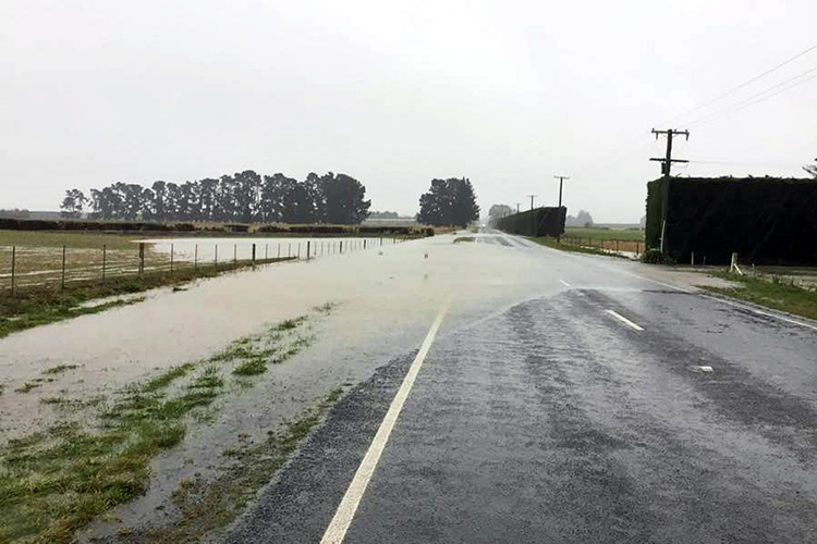
Much of the surface flooding across the district has receded but a number of roads have been damaged by floodwater. Contractors are working as quickly as possible to make these safe until permanent repairs can be made.
Derretts Road, Homebush Road and Malvern Hills Road have reopened this morning. Watsons Road and Washpen Road remain closed, while inspections are in progress at Pig Saddle Road and Scotts Road (Hororata).
Kowai Road is passable but has significant damage. Hanmer Road has a tree down but this has been cleared from the road.
Snow clearing will be undertaken today on Algidus Road and Harper Road
Floodwater may remain on local roads and drivers are urged to be cautious.
Check Selwyn local roads map for the latest updates:
https://www.ramm.com/roadclosures/roadclosuremap.html?region=selwyn
Waka Kotahi NZ Transport Agency advise the last few highways still closed by yesterday’s heavy snowfall should be opening around lunchtime or early afternoon today.
Check latest updates from Waka Kotahi at https://www.journeys.nzta.govt.nz/traffic
Latest MetService updates at: www.metservice.com/warnings/home#central-south
6am update (Wednesday 13 July)
The Selwyn Civil Defence emergency operations centre has been stood down after monitoring river and flood conditions overnight.
Civil Defence and Environment Canterbury were monitoring the Selwyn River until around 1am. The river flow reached a peak height of 3.28 metres at the Ridgens Road station, near Greendale, soon after midnight.
This was below the level considered likely to present a risk to lower lying areas including the Selwyn Huts.
Civil Defence are aware of 10 people who were in temporary accommodation overnight after self-evacuating from Selwyn Huts earlier on Tuesday.
An emergency centre at Lincoln Event Centre was stood down at around 9pm.
Anybody who has had floodwater through their home and has not already contacted the Council, should contact the Council on 0800 SELWYN (0800 735 996), so that any appropriate support and assessments can be arranged.
Rainfall has abated overnight and surface flooding is expected to recede throughout the morning.
Selwyn Civil Defence local controller Helene Faass says agencies are grateful for the assistance of local communities throughout the weather event.
“We appreciated the flow of information from people across the district. This information was extremely helpful in helping us understand the situation and plan our response.
“We also appreciate the support of our community volunteers, and the other agencies and emergency services who were part of this response.”
Civil Defence and Council staff will be assessing conditions from first light today.
Check our local roads map for the latest updates:
https://www.ramm.com/roadclosures/roadclosuremap.html?region=selwyn
Check latest from Waka Kotahi at https://www.journeys.nzta.govt.nz/traffic
Latest MetService updates at: www.metservice.com/warnings/home#central-south
Update 5.30pm
Selwyn Civil Defence activated an emergency operations centre this afternoon to coordinate the response and community support for the severe weather event currently affecting the district and wider Canterbury region.
We’re working with other agencies and emergency services to monitor rainfall and river levels across the district and will be ready to respond if required. Current forecasts indicate rainfall may be easing, which would reduce the rate of river flow increase over the next few hours.
Local Community Reponse Teams are also working in local areas to gather information and identify any community needs.
Flooding
Surface flooding has been widespread in many areas across the district.
Residents of Selwyn Huts have been encouraged to self-evacuate as a precaution. Anyone requiring assistance with evacuation or accommodation should contact the Council on 0800 SELWYN (0800 735 996).
An emergency centre has been set up at Lincoln Event Centre to provide short-term, drop-in support.
Any residents concerned about life-threatening or immediate flooding danger should call 111 and ask for Fire and Emergency.
The Hororata River has breached at Happy Jacks Creek. There is no indication of immediate danger to any property but Civil Defence advise people to self-evacuate if they have concerns.
Civil Defence have assisted with sandbagging for a small number of properties in the Hororata and Sheffield areas, however due to adverse condition no further sandbagging will be available overnight.
Local roads
A number of local roads remain closed. All river fords are closed.
The Leeston Road bridge remains open.
Check our local roads map for the latest updates:
https://www.ramm.com/roadclosures/roadclosuremap.html?region=selwyn
State Highways
SH 77 closed from Darfield to Rakaia River Bridge
SH 73 closed from Springfield to Castle Hill
OPEN WITH RESTRICTIONS
SH73 Castle Hill to Arthurs Pass - Snow - Chains essential & closed to towing vehicles
SH73 Arthurs Pass to Otira - Snow - Chains essential & closed to towing vehicles
Please note as the state highway conditions are quickly changing be prepared for unexpected hazards on the roads.
Please consider delaying your journey and travel only if necessary.
Check latest from Waka Kotahi at https://www.journeys.nzta.govt.nz/traffic
Snow and rain warnings
Heavy snow warning is in place for the Canterbury High Country.
Road snowfall warnings are in place for alpine passes including Porters and Arthurs.
Heavy rain warnings remain in place for much of Canterbury through to at least midnight tonight.
Latest MetService updates at: www.metservice.com/warnings/home#central-south
To check whether you are in a snowfall area, check our snowfall level map at: www.selwyn.govt.nz/services/civil-defence-And-emergency-management/natural-disasters/snowscape
Livestock and animals
Advice about animals in floods can be found in this MPI fact sheet: https://www.mpi.govt.nz/dmsdocument/26527-Animals-affected-by-flood-Advice-for-livestock-lifestyle-block-horse-and-pet-owners
Update 2.45pm – Selwyn Huts urged to self-evacuate
Selwyn Civil Defence is advising residents in Selwyn Huts to self-evacuate as river levels rise in the Waikirikiri/Selwyn River.
Environment Canterbury has issued a warning for rising river levels, and Civil Defence is urging Selwyn Huts residents to self-evacuate as a precaution.
In the first instance residents should try to find accommodation with friends or family.
Anyone requiring assistance with evacuation or accommodation should contact the Council on 0800 SELWYN (0800 735 996).
Any residents concerned about life-threatening or immediate flooding danger should call 111 and ask for Fire and Emergency.
No other evacuation warnings are in place in Selwyn at present.
Update 1pm – roads and rain warnings
- Watsons Rd
- Pig Saddle Rd
- Washpen Rd
- Scotts Rd (Hororata)
- All river fords are closed (including Coes Ford)
Check our local roads map for the latest updates: https://www.ramm.com/roadclosures/roadclosuremap.html?region=selwyn
SH73 on the Canterbury side will be closed all afternoon and possibly overnight. Check latest from Waka Kotahi at www.journeys.nzta.govt.nz/traffic
Latest MetService updates at: www.metservice.com/warnings/home#central-south
To check whether you are in a snowfall area, check our snowfall level map at: http://www.selwyn.govt.nz/.../natural-disasters/snowscape